| The Middle Zambezi River |
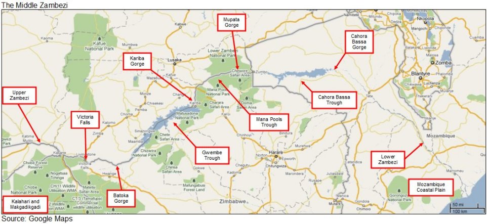
The Middle Zambezi is often known as the river's "trough tract", including that part of its course from Victoria Falls to the Mozambique Coastal Plain. Downstream of Victoria Falls, the river passes through Batoka Gorge, cut within Mesozoic (end-Karoo) basalts before entering the Gwembe Trough, the first of three fault-bounded valleys underlain by Karoo rifted basins. Gwembe now contains Lake Kariba, with Kariba Dam located at the upstream end of Kariba Gorge, the first of three gorges through Proterozoic basement. The Zambezi flows across the Mana Pools Trough within its last remaining stretch of unaltered alluvial channel, which was my principal research area between 1981 and 1991. Downstream of Mupata Gorge, the third trough contains Lake Cahora Bassa, ending at the Cahora Bassa Gorge. This gorge fringes the river as far as the Lower Zambezi, where it crosses the Mozambique Coastal Plain.

| Unique Features |
The Middle Zambezi has not received the attention it deserves. Rhodesia was a British colony that declared independence in 1965, over the issue of black majority rule. Following years of civil war, the country became independent again in 1980, under Robert Mugabe. There followed a period of relative stability for several years, followed by rampant inflation and economic meltdown. For these reasons, it has not been possible to study in sufficient detail the extraordinary opportunities that the country offers for the natural sciences and the implications it holds for global chronologies and processes. Working between 1981 and 1991 with University of Zimbabwe, I was able to discover for myself some of these unique features. I asked and started to answer two important questions:
What implications does the Zambezi have for global climate change?
| Climate Change |
The Zambezi is important to our understanding of global climate change because its catchment, situated in tropical latitudes to the south of the equator, is uniquely placed to record the southern movement of Africa's rain belt. Pleistocene climate change has caused this to move northward and southward, in response to the growth and ablation of ice sheets in both hemispheres. During the Late Pleistocene, the development of extensive Northern Hemisphere ice sheets pushed the rain belts southward, bringing wet conditions to the Kalahari and a dry Sahara. The subsequent Holocene warming saw the rain belts move north of their modern latitudes, making much of the Sahara wetter than it is today.
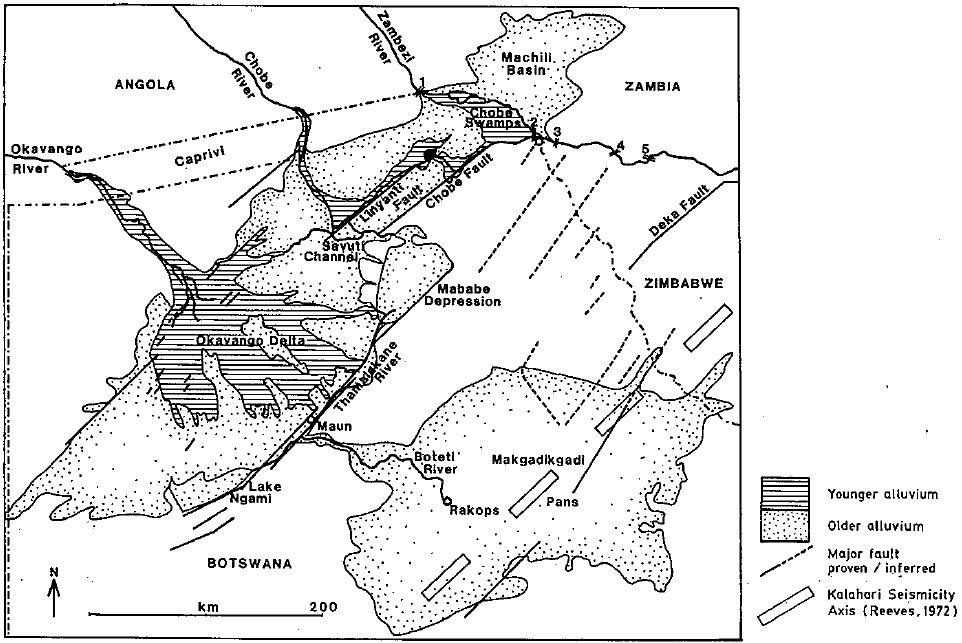
For periods during the Pleistocene, the Makgadikgadi of Central Botswana supported lakes so large that they must have been fed by the great northern rivers: the Okavango, the Chobe and almost certainly the Zambezi itself. Waters of the Okavango now evaporate or infiltrate into its inland delta and the bounding Kalahari Sands. In some years, a portion of that flow spills south eastwards along the Boteti River to re-create a remnant of the palaeo-lake that once covered the pans of the Makgadikgadi (see map below). The Chobe now flows north eastwards along the base of fault scarps, joining the Zambezi at Kazangula. In some years, a portion of its flow is diverted south to the Mababe Depression. The Zambezi itself flows eastwards, to the Victoria Falls and thence to Gwembe. What conditions once fed the waters of Palaeo-lake Makgadikgadi and what changes caused it to disappear?
My own contribution was to identify Stoney Ridge at Mana as a cataclysmic flood deposit, recording the capture of the Upper Zambezi catchment by the Middle Zambezi. Working at Mana, I found some 30m of post-Karoo alluvium underlying the Stoney Ridge. The Zambezi has cut down through this sequence to its modern (pre-Kariba) channel, where it is controlled by the underlying Karoo (Mesozoic) sediments. I realised that this sequence implies that capture occurred through climate change and overtopping of the lake upstream, rather than erosion cycles instigated by uplift at the coast. I dated river capture from the published record of the Stone Age archaeology to the Last Interglacial, at about 125,000 years ago.
Why should warmer conditions have led to Southern Africa becoming wetter? Warming during the Holocene led to the opposite effect, a wetter Sahara and presumably a drier Kalahari. It has been suggested by others that the period around 125,000 years ago involved collapse of the ice sheet over West Antarctica and while circumstantial, the sequence on the Zambezi's catchment is consistent with that hypothesis. Additional work is required to better establish the chronology of capture and how it fits within the global framework.
| Landscape Evolution |
Having once occupied a central location in the super-continent of Gondwanaland, the Zambezi is important to understanding landscape evolution because the catchment includes landscapes of at least three different ages, from the very old to the very youthful. The oldest landscapes occur within the troughs and their age is revealed by their relationship to the bounding rift valleys. Between the troughs, the course of the Zambezi through both Kariba and Mupata Gorges is anticedent to the surface expression of the underlying lithologies. At both locations, the Middle Zambezi River leaves the Mesozoic sediments of the rift valleys and follows courses through much harder basement rock.
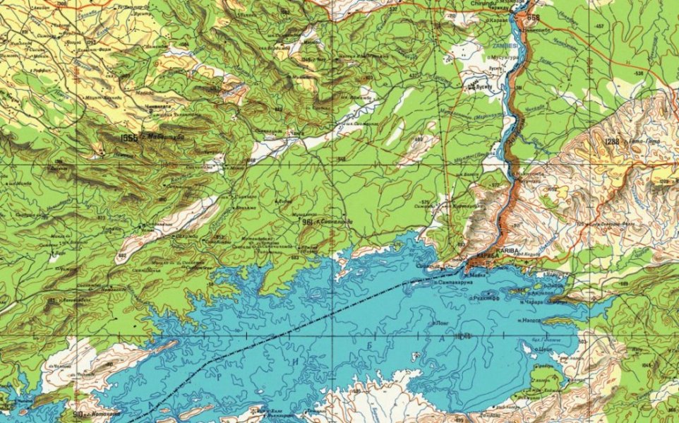
Had the drainage system been instigated in modern times, it would have taken routes across the less resistant Karoo lithologies, which are now topographically lower, to the west and north of Kariba Gorge (see map below) and to the south of Mupata Gorge. The fact that it does not, means that the age of the river at the gorges can be traced back to before the start of rifting. That is, to the base of the Karoo, to the period of glaciation known as the Dwyka that affected a large part of Gondwanaland and records the passage of the continent across the South Pole. In terms of northern hemisphere stratigraphy, the Dwyka glaciation occured during the Carboniferous and Permian. The anticedant drainage at the gorges implies that landscapes within the gorges and bounding troughs have evolved since the Late Palaeozoic.
Topography around Kariba Gorge

Source: http://www.madmappers.com/mapset.php?MS=183
Why have these landscapes of such different ages not already received considerable attention? Part of the answer lies in the political uncertainty described above but part stems from the dominant theory of African landscape evolution since the 1940s, which held that the surfaces of the Southern African interior were the product of repeated episodes of landscape rejuvination. This "pediplanation" paradigm, ascribed to the South African geomorphologist Lester C. King, suggested that uplift at the coast instigated erosion cycles which worked their way inland. Victoria Falls was interpreted in these terms, as the point reached by the most recent such cycle. It follows that landscapes downstream would be older, having previously experienced the passage of the knick point, but not very much older. This theory was able to explain the widespread occurence of surfaces in African landscapes.
An alternative explanation is that surfaces formed through long periods graded to different base levels, both at the coast and local base levels within the interior. Catchments were affected by continental rifting and more recently by climate change, which was able to initiate river captures and create the network that exists today. Failure to realise that elements of the landscape evolved from several discrete events and the great differences in their ages has led to failure to adequately investigate and interpret the implications for landscape evolution. This is a pity, not least because lessons from the evolution of the Zambezi catchment may have implications for the development of landscapes elsewhere.
Chris Nugent, January 2012
